Malaysian Ringgit


CAPTURE
Capture RGB, thermal, or multispectral images with any camera. If using a drone, automate flight and image-data transfer with the free Pix4Dcapture mobile application.
DIGITIZE
Pix4Dmapper transforms your images into digital spatial models and maps.
Seamlessly process your projects using the cloud or desktop photogrammetry platforms.
CONTROL
Assess and improve the quality of your project. The quality report gives a preview of the generated results, calibration details, and many more project indicators.
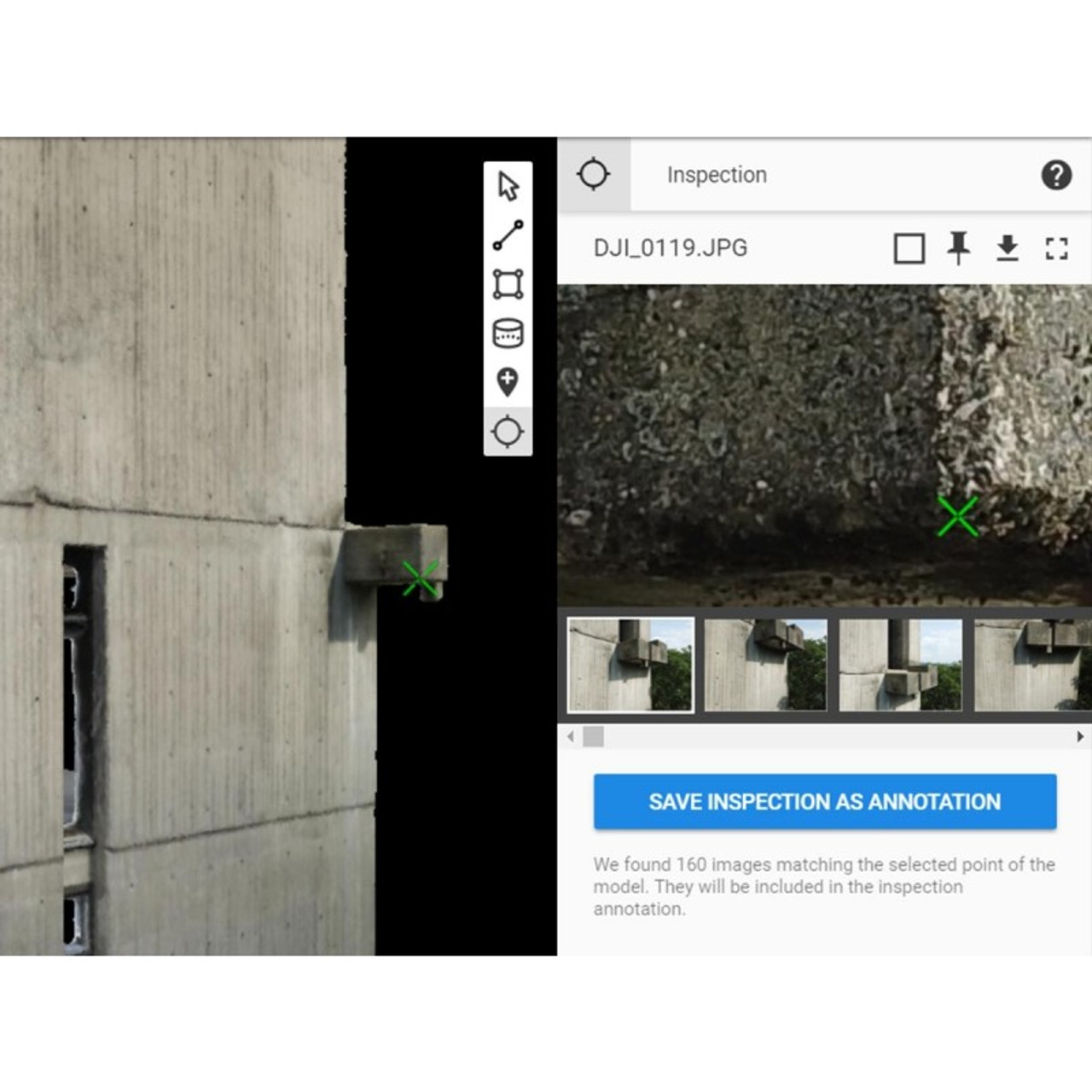
MEASURE AND INSPECT
Measure distances, areas, and volumes.
Extract elevation profile data and perform virtual inspections.
COLLABORATE AND SHARE
Streamline project communication and teamwork. Build trust with your clients.
Selectively and securely share project data and insights with your team, clients, and suppliers.
A variety of tools to power applications across industries
- Survey-grade results
- Obtain results with sub-centimeter accuracy
- 1-2 pixel GSD in X, Y directions
- 1-3 pixels GSD in the Z direction
Complete control over your project
Define an area of interest, select processing options, add ground control points or edit point clouds, DSMs, meshes, and orthomosaics.
Your workflow, your choice
Use default templates for automatic processing, or custom settings for full control of quality, data, and projects. Choose when and how to use the cloud and desktop processing.
rayCloudtm
The power of photogrammetry software
A unique environment connecting your original images to each point of the 3D reconstruction to visually verify and improve the accuracy of your project.
Accurate 3D maps and models, purely from images
- Automatic point cloud classification
- Flatten and smooth digital surfaces
- Easily measure surface, distance, volume, and elevation
- Inspect and annotate
- Collaborate and share
Any camera. Any drone. Any imagery. As long as it's a .jpg or .tif file.
- RGB ground images
- Drone images
- Multispectral Images
- Thermal Images
- Fisheye Images
- 360° Camera Images
- Camera Rig Images
- Videos
Your projects. Your tools.
Easily export your digital maps and models to industry-compatible formats for further analysis or reporting.
- Full-color Point Cloud - .las, .laz, .ply, .xyz
- Orthomosaic - GeoTiff (.tif), .kml
- Digital Surface Model (DSM) - GeoTiff (.tif), .xyz, .las, .laz
- 3D Textured Mesh - .ply, .fbx, .dxf, .obj, .pdf
- Index Map - GeoTiff (.tif), .shp
- Thermal Maps - GeoTiff (.tif)

Related Products